
[ad_1]
“Since record keeping began in 1949, this is the strongest hurricane to make landfall in May along the Pacific coast of Mexico,” the Hurricane Center tweeted.
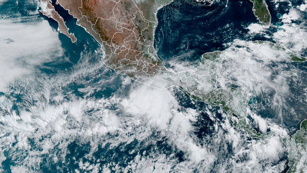
4pm CDT 30 May – #Hurricane #Agatha has made landfall just west of Puerto Angel, Mexico, with maximum sustained winds of 105 mph.
Since record keeping began in 1949, this is the strongest hurricane to make landfall in May along the Pacific coast of Mexico. pic.twitter.com/dUraseRoDe
— NHC Eastern Pacific (@NHC_Pacific) May 30, 2022
While strengthening to a Category 2 hurricane on Sunday, Agatha passed over warmer-than-normal waters which helped fuel the storm’s intensification. Warming ocean temperatures in the tropics have been tied to human-caused climate change.
As Agatha moves inland, the Hurricane Center warns the storm will unleash “life-threatening” winds and an “extremely dangerous” ocean surge.
Both along the coast and through the interior of southern Mexico, the storm also poses a threat “of potentially life-threatening flash flooding and mudslides,” according to the center.
Agatha became just the third hurricane to strike Mexico from the eastern Pacific Ocean during May and was the strongest of the bunch.
Later this week, there are increasing chances that the storm’s remnants will enter the Gulf of Mexico and become part of a new system that could bring some stormy weather to Florida by the weekend.
For now, a hurricane warning covers the zone from Salina Cruz to Lagunas de Chacahua in Mexico’s Oaxaca state, with tropical storm warnings to the north and south.
The Hurricane Center predicts the following effects from the hurricane:
- “Life-threatening” hurricane-force winds near where the center crosses the coast in Oaxaca through Monday evening.
- “Extremely dangerous” coastal flooding from the ocean surge, or a storm-driven rise in water above normally dry land, near and to the east of where Agatha’s center makes landfall. “Near the coast, the surge will be accompanied by large and destructive waves,” the center writes.
- The potential for “life-threatening flash flooding and mudslides” in the Mexican states of Oaxaca and Chiapas through Tuesday, with up to 15 to 20 inches of rain in the high terrain.
Agatha is expected to fall apart crossing the rugged terrain of southern Mexico, but its remnants may enter the southern Gulf of Mexico in the Bay of Campeche by midweek.
The Hurricane Center writes they may get drawn into a “large and complex area of low pressure expected to develop across Central America, the Yucatán Peninsula, and the southwest Gulf of Mexico.” There’s a 40 percent chance the low pressure zone develops into a tropical depression or storm, the center says.
8 AM EDT May 30- There is a medium chance of development by late this week from a large and complex low pressure area that is expected to develop over the southwestern Gulf of Mexico, Yucatan Peninsula, and the northwest Caribbean Sea. Follow the latest at https://t.co/tW4KeFW0gB pic.twitter.com/U4sv9Rg42G
— National Hurricane Center (@NHC_Atlantic) May 30, 2022
Some computer models show the low pressure zone bringing rain to Florida by late in the week or the weekend but it’s unclear if environmental conditions will support more than a weak storm.
If a storm forms, it will earn the name Alex and become the first storm of the Atlantic hurricane season, which officially begins on June 1.
[ad_2]
Source link


